
Jeremy Ratliff
Editor
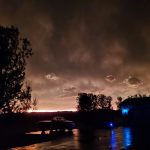
What began as the hottest day of the year last Friday, July 19, soon became one of the most destructive nights in years for some areas, as severe thunderstorms and straight-line winds wrecked havoc across northern and central Wisconsin.
The powerful storms impacted the area much sooner than expected and resulted in a busy night for local public safety agencies.
As Merrill Fire Chief Josh Klug explains, the Merrill Fire Department responded to its first storm-related call at approximately 8:03 p.m, Friday evening, for a downed wire on 12th Street.
Preliminary information indicated the wire was possibly on fire, but upon arrival, the fire had been put out.
That call would be the first of many for the Merrill Fire Department personnel on-duty Friday night, as they would go on to respond to 15 weather related calls.
“We had a combination of calls from downed wires with small fires and fire alarm issues in buildings, to patients with medical needs and people with no power. We also responded to a vehicular accident from driving during the storm,” Klug explains.

Photo Courtesy of Teresa Wolf
“We were fortunate that night to be able to utilize some of our off-duty staff from callback, otherwise we couldn’t have handled all those calls without delay.”
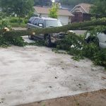
Saturday afternoon, Merrill Fire Department personnel joined those from the four area volunteer fire departments of Corning, Pine River, Russell and the Tomahawk Fire Department, in responding to a mutual aid request from storm ravaged eastern Langlade County. Deployed personnel assisted with opening roads and performing welfare checks on residents who were trapped in their properties due to trees covering roads and driveways. On Sunday most departments returned to Langlade County to provide water for residents lacking electricity.
According to Klug, 15 MFD personnel assisted in Langlade County for approximately nine hours.
The Lincoln County Sheriff’s Office was also kept quite Friday night and Saturday.
According to LISO Communications Administrator Lieutenant Tim Fischer, the sheriff’s office’s E-911 Communications Center handled 111 calls regarding the storm, fourteen of those from other counties whose 911 centers where overwhelmed causing the calls to ring through to Lincoln County. The first report of damage during Friday night’s storm came through at 7:24 p.m. when a tree fell and blocked USH 8 near Tripoli. All five fire departments in the county were dispatched on a range of calls throughout the storm including downed trees on power lines and homes filling with smoke.
While many suspect the storms experienced this weekend were a result of Friday’s daytime heat, the energy mother nature unleashed Friday night had in fact been building for days, as explained by WJFW-Rhinelander Meteorologist Geoff Weller.
“The atmospheric setup Friday night was explosive and doesn’t happen very often. A large area of heat and humidity was building for days across the Midwest. Around this heat, thunderstorms like to form in the contrast between the heat and the cooler temperatures to the north. Friday started with a dying area of thunderstorms across eastern Minnesota. These thunderstorms spread further east than originally thought. Dying thunderstorms push out air and put out outflow boundaries, along which other thunderstorms like to develop. Because the atmosphere was so explosive Friday, this was the trigger that was needed to initiate new thunderstorms that quickly became severe across northern Wisconsin.”
As he further explains, while not necessarily the sole culprit of Friday’s storms, the heat in the area became fuel of sorts for the newly formed storm front, causing the storms to propel faster along it’s trek and hence arriving much earlier than anticipated Friday evening.
“The timing was awful either way,” he adds.
“Thunderstorms like to tap into the heat of the day and the peak of daytime heating is late afternoon. With the humidity, “feel-like” temperatures were near 100° as far south as Portage county Friday afternoon. As soon as the new thunderstorms developed, a low level jet stream punched in from the west. This is a river of cooler, more dense air that can transport winds a few thousand feet above the earth’s surface, back down to the earth’s surface via downdrafts. The entire system is meteorologically called a MCS or Mesoscale Convective System.
“This is an organized complex of thunderstorms that typically produces squall lines for several hundred miles across the midwest during the summer. The one we experienced Friday traveled 485 miles and lasted over 10 hours, from eastern Minnesota into lower Michigan. Radar indicated winds out of the west at 101 miles per hour at times, just above the earths surface as this system moved across northern Wisconsin.”


Weller confirms previous reports of nine tornadoes having formed across central and northern Wisconsin, but he also points out how the scenario could have been much worse.
“The nine tornado reports have all been EF-0 to EF-1. These produce wind speeds generally around 100 mph. The potential was there
for even stronger EF-2 EF-3 tornadoes. These are the tornadoes that completely destroy structures. For example the Merrill tornado from April 10, 2011 produced a EF-3 tornado. This had winds of 130-140 mph with a path of 21.2 miles. 22 homes and 7 businesses were
destroyed. This event had the potential to produced tornadoes like that, but thankfully didn’t.”
Most of the damage sustained in neighboring areas Friday and Saturday morning was a result of straight-line winds. Contrary to popular belief, straight-line winds are much different than a standard wind pattern and can be even more destructive than tornadoes.
“Straight-line winds are what are produced from the wind energy I discussed earlier,” Weller explains. “That are just above the earth’s surface before being transported down to the Earth’s surface. This is always sporatic in nature, as the river of quick moving horizontal air gets under or pokes through a downdraft within the thunderstorm to transport all of it’s energy to the Earth’s surface. We have seen images come in this weekend depicting an entire forest completely blown over with trees snapped in half, while 100 feet away, there is no damage whatsoever. Lincoln county got lucky and largely missed the destructive winds from this system, as the thunderstorms intensified over the county, before moving east. This is normal with systems like this, as they tend to lose and gain energy as they progress.”
While storms with the level of power and ferocity seen this weekend are rare, the chances of a recurrence yet this summer are not completely out of the question, accoring to Weller.
“Climatologically, the warmest week of the year is now behind us. Still, June was the hottest month on record globally. If heat were to build across the Midwest again, with a sharp contrast between the cooler air to the north., a similar atmospheric setup can be created. With that said, none of the long range forecasts predict this.”
The Merrrill area was also spared in terms of rainfall this weekend, compared to other areas. While Merrill measured 1.67” of rain, Tomahawk logged 2.35” Radar indicated wind speeds of 60 mph in the Merrill area Friday night.